The most important question to answer about hurricanes is: what's your evacuation plan?
Between 1885 and 1996, nearly 40 percent of the hurricanes that affected Florida hit the panhandle between Alabama and Apalachicola. The Panhandle and South Florida have the state's highest probabilities of getting hit with hurricane-force winds in any given year. Here are the odds calculated by the National Weather Service (Henry et al., 1994):
| Place | Odds of getting hurricane-force winds in any given year |
| Jacksonville | 1 in 100 |
| Apalachicola-St. Marks | 1 in 17 |
| Pensacola | 1 in 8 |
| Miami | 1 in 6 |
Hurricanes are rated according to their wind speed and height of storm surge. Here's the scale (National Climatic Data Center, 2001):
| Saffir/Simpson Scale for classifying hurricanes | |||
|
Category
1 |
Winds(mph)
74-95 |
Surge (ft)
4 - 5 |
Damage
Minimal |
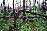
 Trees snapped by high winds in the Apalachicola National Forest near Sopchoppy (photo by Karla Brandt) |
History shows that the damage a hurricane can do is not necessarily just a matter of wind. Flooding, from storm surge or heavy rain or both, has caused tremendous heartbreak in the region, too. Here are projected storm surges for various places in the ARROW region for storms of varying strengths. Even though the labels- 50-year, 100-year, 500-year-sound as though they only happen once in 50, 100, or 500 years, that's not true. The odds of a 50-year storm coming along in any given year are 1 in 50, or 2 percent; a 100-year storm's odds are 1 in 100, or 1 percent; and a 500-year storm's odds are 1 in 500, or 0.02 percent. Every year, the clock starts over, so if we had a 50-year storm last year, there would still be a 1 in 50 chance that we'd get another one this year.
| Peak Storm Surge Height (feet above National Geodetic Vertical Datum) using the Florida Department of Environmental Protection Storm Surge Model (Sheppard and Miller, 2003) |
|||
| Location, County | 50-year | 100-year | 500-year |
| Beacon Hill, Gulf | 10.1 | 11.7 | 16.3 |
| St Joseph Point, Gulf | 8 | 9.3 | 12.6 |
| St Joseph Park, Gulf | 7.7 | 8.8 | 11.9 |
| Cape San Blas, Gulf | 9.3 | 11.1 | 16 |
| McNeils, Gulf | 10.8 | 12.4 | 16.9 |
| Indian Pass, Gulf | 11 | 12.6 | 17 |
| St Vincent Island, Franklin | 10.1 | 12 | 14.7 |
| West Pass, Franklin | 10.2 | 12.1 | 15.1 |
| Sikes Cut, Franklin | 10.2 | 12.3 | 15.4 |
| St George Island, Franklin | 10.5 | 12.6 | 16 |
| Dog Island, Franklin | 11.5 | 13 | 16.4 |
| Alligator Harbor, Franklin | 12.2 | 14.7 | 18.7 |
| Lighthouse Point, Wakulla | 13.1 | 14.7 | 17.3 |
| Shell Point, Wakulla | 13.3 | 15.1 | 17.3 |
| Goose Creek Bay, Wakulla | 13.5 | 15.3 | 17.8 |
| Whale Island, Wakulla | 13.9 | 15.3 | 18.1 |
| Palmetto Island, Wakulla | 14.2 | 15.5 | 18.3 |
| Little Redfish Point, Wakulla | 13.9 | 15.2 | 17.9 |
 |
In fact, a storm doesn't even have to qualify as a hurricane to create world-class havoc. According to an account assembled by three newspapers (The Macon Telegraph et al., 1994), Tropical Storm Alberto made landfall in Destin late in the morning of July 3, 1994. By the next day the storm had traveled nearly to Atlanta, where it ran out of locomotion -- but not out of rain. By July 5, it had rained for 86 hours, and by the time the storm finally moved back south and out to sea, 33 people had lost their lives. Some were swept away in their cars, and some died trying to rescue others or make emergency repairs. Close to 60,000 people had to leave their homes, and many lost everything. Florida towns that were flooded include Chipley, Careyville, Bristol, and Blountstown. Many more cities and towns in Georgia were inundated. Tropical Storm Alberto never became a hurricane. Nevertheless, it destroyed roads, bridges, cars, boats, railroad tracks, public water systems, houses, businesses, farms -- and lives.
Sources:
Henry, J.A., K.M. Portier, and J. Coyne. 1994. The climate and weather of Florida. Pineapple Press, Sarasota, Florida.
National Climatic Data Center. 2001. The Saffir/Simpson hurricane scale. National Oceanic and Atmospheric Administration. Available at Satellite Gallery.
Sheppard, D.M., and W. Miller Jr. 2003. Design storm surge hydrographs for the Florida coast. FDOT Contract Number BC-354 RWPO 70. University of Florida Contract Number 4910 45-04-920. Department of Civil and Coastal Engineering, University of Florida, Gainesville. Available at Florida DOT Drainage Research Projects page.
The Macon Telegraph, Tallahassee Democrat, and Columbus Ledger-Enquirer. 1994. Deluge! The flood of '94. Andrews and McMeel, Kansas City.
Note: The content of the website has not been updated since 2005. The site remains online for it's value as legacy content and is unlikely to be updated.