Water: Aquifers
Treasure Beneath Our Feet
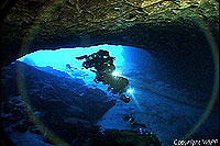
 A diver explores the aquifer that feeds Wakulla Spring (Photo courtesy Woodville Karst Plain Project) |
But isn't rock supposed to be solid? Not all rock is the same, and aquifers are found in various kinds of earth layers, from sand and gravel to limestone, sandstone, and even marble. In the ARROW region, our main source of water is in a series of layers of porous rock called carbonate rock, and it's composed mostly of limestone or dolomite. In the United States, aquifers in carbonate rocks are also found in the southwest, northern midwest, and northeast.
Recipe for a Carbonate-Rock Aquifer
Dissolve ions and atoms in the ocean. Allow to combine. Repeat recipe an unfathomable number of times, and the ingredients will form a solid substance that precipitates (literally, rains!) out of the water. Add pressure from the weight of the ocean; let the substance sit until well compacted. Lower the level of the ocean so it no longer covers the rock. Expose the rock to rainfall that contains acids from the soil, which dissolves the rock here and there and is also stored in the porous rock, and presto! You've got yourself the Floridan Aquifer.
The aquifer system of greatest importance to the ARROW region is the Floridan. It's not just under Florida; it extends into South Carolina, Georgia, Alabama, and Mississippi. The Floridan is the source of most of the region's drinking water. It's replenished by rainfall percolating through the soil and into the rock, a process hydrologists call "recharge." In some places, particularly where the Floridan is close to the earth's surface and isn't covered by a thick, nearly impenetrable layer of clay, the recharge rate is very high. In other places, where the aquifer is "confined" -- that is, held under a nearly impenetrable "confining" layer--recharge is very slow. Water is discharged from the aquifer through springs, which may emerge on land or underwater along the coast of the Gulf of Mexico. People extract water from the aquifer by pumping it.
Sources:
Fernald, E.A., and E.D. Purdum (eds.). 1997. Water resources atlas of Florida. Institute of Science and Public Affairs, Florida State University, Tallahassee.
Miller, J.A. 1999. Ground water atlas of the United States. U.S. Geological Survey. Available at Ground Water Atlas.
Note: The content of the website has not been updated since 2005. The site remains online for it's value as legacy content and is unlikely to be updated.