History: ARROW Region
Timeline of the region
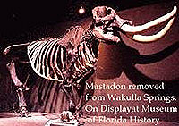 Photo courtesy Florida Division of Historical Resources |
AD 200-900
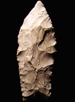 Photo courtesy Florida Division of Historical Resources |
“These [people] live in wigwams, or cabins built of bark which are made round, like an oven, to prevent any damage by hard gales of wind. They make the fire in the middle of the house and have a hole at the top of the roof right above the fire, to let out the smoke. These dwellings are as hot as stoves, where the Indians sleep and sweat all night.” John R. Swanton, The Indians of the Southeastern United States, Bulletin 137, Bureau of American Ethnology, Smithsonian Institution, 1946
AD 900-1500
Thousands of Native Americans of what is known to today's archeologists as the Ft. Walton culture thriving, engaging in intensive agriculture, growing corn and other crops. The Cayson Mound and village complex in the vicinity of Blountstown on the Apalachicola River may have been a regional center of this culture.
1513-1763 First Spanish Period
1528
Spanish explorer Panfilo de Narvarez and his small army traveled through the region. One possible route proposed by Donald E. Shepard (“Cabeza de Vaca's Journey-Florida Trails,” http://www.floridahistory.com/vaca-1a.html) crossed Gum Swamp, East River Pool, and the St. Marks River, then passed a plain north of today's Medart, Sopchoppy, Ochlockonee, and New River swamps, and a big stream they called “Magdelena” (the Apalachicola).
“The country is mostly level; the soil is sand and earth. All throughout it there are very large trees and open forests containing nut trees, laurels and others of the kind called resinous, cedar, juniper, wateroak, pines, oak and low palmetto, like those of Catilla. Everywhere there are many lagoons, large and small, some very difficult to cross…The animals were three kinds of deer, rabbits and hares, bears and lions and other wild beasts, among them one that carries its young in a pouch on its belly….The country is very cold; it has good pasture for cattle; there are birds of many kinds in large numbers: geese, ducks, wild ducks, muscovy ducks, ibis, small white herons (egrets), herons, and partridges. We saw many falcons, marsh-hawks, sparrow-hawks, pigeon hawks, and many other birds.” --Alvar Nunez Cabeza de Vaca, chronicler of the Narvarez expedition, translated by Fanny Bandelier (1905)
1539
Hernando de Soto and his men travel through Florida and into Georgia. De Soto's exact route is matter of debate. Charles Hudson (in Jerald Milanich and Susan Milbrath, First Encounters: Spanish Explorations in the Caribbean and the United States) believes De Soto traveled north out of Florida east of the Apalachicola River and then crossed the Flint River in Georgia. Independent researcher Donald E. Sheppard (http://www.floridahistory.com/inset6.html) believes that de Soto camped on a plain on the east bank of the Apalachicola and after taking several days to construct a bridge crossed the Apalachicola at the site of present-day Chattahoochee.
1600s
Four Spanish missions established among the Indians in the area of the Apalachicola: two along the river and two farther west. One mission, known as Sabacola, established on the upper Apalachicola just below the confluence of the Chattahoochee and the Flint. The Spanish refer to the Apalachicola River as the River of Santa Cruz.
1679
Spanish build Fort San Marcos at today's St Marks to protect the Apalachee mission; French raided the fort in 1682.
1689
Apalachicola Fort was established on the west bank of the Chattahoochee at the confluence of the Flint River. The fort was abandoned 2 years later.
1745
Spanish establish trading post at St. Marks. Creek Indians establish towns in the area under Secoffee, son of Brim.
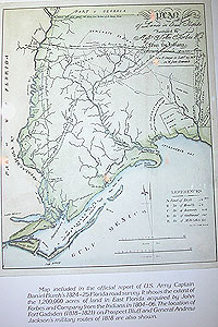 Map of Forbes Land |
1784-1821 Second Spanish Period
1785-1830
Panton, Leslie and Company, established in 1785, headquartered in Pensacola. After 1805, the company was known as John Forbes and Company. The company trades guns and other English-made goods with the Indians for deerskins and other furs. The Indians soon find themselves heavily in debt and trade large tracts of land to cancel their debts. This land, eventually more than 1 million acres on both sides of the Apalachicola, is referred to as the Forbes Purchase, and the purchase is approved by the Spanish government.
Early 1800s
Steamboats develop and for the next 30 years became way of life on the Apalachicola. Bristol depends on steamboat traffic for its livelihood.
1815
At the end of the War of 1812, Major James Nichols the British commander transfers his troops and his Indians and Negro allies to Prospect Bluff on the Apalachicola River where they construct a fort. Pressured by Spanish authorities, Nichols and his British soldiers leave the fort and all its arms with the Indians and former slaves. Those who remain harass river traffic, disrupting this important supply line to the Americans' Fort Scott river on the American-Spanish border.
Early on the morning of July 27, 1816, a ground force under the command of Colonel Duncan Clinch supported by two gunboats attack the fort. One of the first shots from one of the gunboats hits the powder magazine, killing 270 of the 320 persons in the fort, leaving only three uninjured.
1818
Andrew Jackson marches down east bank of the Apalachicola to the site of the British Negro Fort and instructs his aide-de-camp James Gadsden to build a new fort which Jackson named Fort Gadsden in his honor.
1820
Colin Mitchell purchases the Forbes lands.
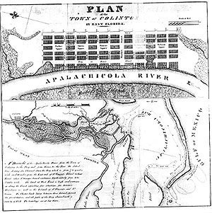 Planning map of Colinton. Photo courtesy Florida Photographic Archives. |
1821
Colin Mitchell lays out the town of Colinton at a place called Prospect Bluff (Fort Gadsden) on the Apalachicola River….”on a fine level plain of pine land, 15 feet above the river at low water, and within the purchase made by J. Forbes and Co. from the Indians. The town lots are 60 feet wide and 120 feet deep. The water lots are 75 feet wide, and form 160 to 300 feet deep. The swamp land under the bluff is from 70 to 90 feet wide, and is sufficiently firm for excellent foundations for wharves at a small expense….The Apalachicola and Chattahouchie Rivers are navigable at all times for large Steam Boats 220 miles in a direct line to the Falls above Fort Mitchel, and run through a fine fertile country, the produce of which must descend these Rivers by Colinton to the Ocean.”
Sketches, Historical and Topographic of the Floridas, 1821
Mitchell's claim to the land was found invalid and the town never became more than a dream and lines on a map.
1820s
Town of Apalachicola founded.
1821
Spain cedes East and West Florida to U.S. Florida becomes a territory of the United States.
1821
President James Monroe sets up a customs district that stretches from Cape Florida to the Apalachicola River.
1822
Jackson County established.
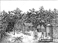 Drawing of Creek Indian village, by Francis comte de Castelnau. Photo courtesy Florida Photographic Archives. |
1823
Gadsden County established.
1823
District of Apalachicola established.
1823
William Simmons of St. Augustine and John Lee Williams of Pensacola meet at the old Spanish settlement of St. Marks and select Tallahassee as capital of the territory of Florida.
1825
Campbellton Baptist Church established. The church was first organized as the Bethlehem Baptist Church and is reputed to be the oldest Baptist Church in Florida. The present church building established in 1858.
1827
Ferry across Apalachicola at Aspalaga landing begins.
1827
Webbville Post Office established. Webbville is the principal commercial center of Jackson County.
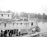 The Fannie Fearn steamboat on the Apalachicola River. Photo courtesy Florida Photographic Archives. |
1828
The steamboat Fannie Fearn's begins her travels from the Gulf to Columbus, Georgia.
1829
Campbellton post office established.
 Photo courtesy Florida Photographic Archives. |
1831
The town council changes the name of the town from West Point to Apalachicola. Before “Westpoint,” the town was known as Cottonton.
1832
Franklin County established.
1832
Botanist Hardy Bryan Croom leases a plantation near Aspalaga Landing. Croom later discovers the rare Florida torreya tree.
1833
Lighthouse constructed at western tip of Little St. George Island.
 Photo courtesy Florida Photographic Archives. |
1835-42
Second Seminole War involves ten thousand Flint-Chattahoochee Creeks who refused to move West.
1836
Apalachicola Land Company holds a series of land sales. The company lays out lots and provides for streets, a square, a courthouse, a cemetery and churches. Purchasers of lots fronting the river required to build sturdy wharves and to construct 3-story, fire-proof brick buildings.
1836
Apalachicola Land Company dredges the harbor.
1837-1850
After New Orleans and Mobile, Apalachicola is the Gulf's third largest port.
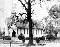 St. Luke's Episcopal Church in Marianna. This building, the third of four on the site, was constructed in 1878 but destroyed by fire in 1941. Photo courtesy Florida Photographic Archives. |
1840
Population of Apalachicola reaches 1,030.
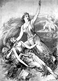 Matt Morgan drawing in Frank Leslie's Illustrated Newspaper personifying yellow fever dragging down Florida as Columbia rushes to the rescue. Photo courtesy Florida Photographic Archives. |
1842
The port of Apalachicola ships 48,070 bales of cotton to domestic markets and 38,794 bales abroad.
1845 Florida becomes a state.
1845
Dr. John Gorrie of Apalachicola invents an ice-making machine and develops a process for cooling a room artificially after he observed that patients with fevers benefited from a drop in room temperature.
1845
Greenwood Baptist Church established.
1848
Light constructed on Cape St. George. The light was downed by hurricane in 1851 and replaced in 1852.
1850s
Oysters packed in barrels and shipped to neighboring states and northern markets.
1851
Dr. John Gorrie's ice machine patented.
1852
Cape St George lighthouse built.
1855
Liberty County established from Gadsden County.
1856 (November 25)
Writer for Bainbridge Argus notes of Apalachicola: “Blow out the Flint and the Chattachoochee rivers and what would be the condition of this flourishing city?”
1857
U.S. Coast Survey, Preliminary Survey of the mouth of the Apalachicola River.
1860
Apalachicola resident Alvan W. Chapman publishes Flora of the Southern United States.
1861 (January 10)
Florida becomes the third state to succeed from the Union, after South Carolina and Mississippi. At the secession convention in Tallahassee, McQueen McIntosh of Franklin County introduces the secession resolution. Florida uses military force to seize the federal arsenal at Chattahoochee
Union forces take control of St. George and Dog islands.
1862 Federal blockade of Apalachicola.
“Starvation was avoided because of the large numbers of fish and oysters in the bay ….people could not avail themselves of the wild cattle and hogs that flourished on St George and St Vincent Islands,” William Warren Rogers and Lee Willis, III, At the Water's Edge
Confederates place batteries and obstructions (heavy chains) at the Narrows above Apalachicola and at Rock Bluff below Chattahoochee
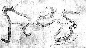 Hosford's map of the Apalachicola River. Photo courtesy Florida Photographic Archives |
186?
George Washington Scott draws map of Apalachicola River and of area from St. Marks lighthouse north, including roads, trails, and railroads.
1863
Federal forces raid Apalachicola and seize ammunition and cotton.
1864 (September 27)
Union forces penetrate inland from Fort Pickens as far as Governor's Milton's hometown of Marianna.
1865 (March 6) Battle of Natural Bridge near St. Marks
Local militia, a cadet corps from West Florida Seminary, and a few regulars defeat a force of 1,000 Union soldiers and protect the capital of Tallahassee from capture.
1866
Apalachicola ships more than a hundred thousand bales of cotton.
1873
Oliver Hudson Kelley founds the town of Carrabelle. He builds the Island House, which is managed by his niece Carolyn Aarrabelle Hall. He names the town in her honor.
1875
St. Teresa settled by residents of Tallahassee as a summer retreat.
Early 1880s
James Coombs establishes a store and sawmill in Apalachicola
1880s
Cebe Tate of Sumatra gets lost and lives to tell the story. The name Tate's Hell is derived from his account of the ordeal.
Large parts of St. George become the property of the Humphries family. The island has timber, turpentine, cattle, and wild hogs. The steamer Crescent City carries people twice a week to the island.
1881
State law awards commercial oyster planting and harvesting rights in designated waters to individuals.
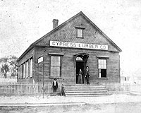 Photo courtesy Florida Photographic Archives |
1889
Florida Fishing Commission created.
1890s
Edward Porter becomes the lighthouse keeper on Little St. George Island. He builds a cottage and a storm house and grazes as many as 250 head of cattle and 200 hogs and maintains a large vegetable garden.
1896
Quaker David Brown, his family and others found Eastpoint as a cooperative enterprise, the Co-Workers Fraternity. The profits from lumbering, fishing, and manufacturing were to be shared.
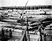 Photo courtesy Florida Photographic Archives |
Early 1900s
Greek spongers come to Apalachicola.
Canneries for oysters and other seafood established in Apalachicola.
The way to Tallahassee from Apalachicola was by boat and train. The boat, a beautiful sidewheeler Crescent City made daily trips from Apalachicola to Carrabelle. Every morning the train ran from Carrabelle through Tallahassee to Cuthbert Georgia; Lanark Village community built and owned by the Georgia, Florida, and Alabama Railroad, fashionable resort including the Lanark Inn attracted people form Florida and Georgia.
1900 (August 22)
Electricity comes to Apalachicola.
1900 (May 25)
Great fire in Apalachicola started by sparks from wood cookstove. The fire destroyed six city blocks.
1907
Gibson Inn built (originally known as the Franklin Hotel)
1907
Dr. Ray V. Pierce, a patent medicine manufacturer from Buffalo, New York, purchases St. Vincent Island and converts it to a game preserve.
Completion of the Apalachicola Northern Railroad from River Junction in Gadsden County, 70 miles of tracks link with east-west Florida lines.
1909-1910
Branch of Apalachicola Northern Railroad from Apalachicola to St. Andrew Bay results in the founding of Port St Joe near the long vanished St. Joseph.
1910
Dreamland, Apalachicola's first movie house, opens.
1911
Club House opens on St. George Island. The facility serves meals and rents bating suits and boats to guests.
1913
Dixie Theatre in Apalachicola opens.
1918
Worldwide flu epidemic.
17 million acres of pine or lost to wildfires. In some places, sugarcane replaced pine.
 Map of Apalachicola Bay and surrounding land, ca. 1921. Courtesy Florida Photographic Archives. |
1922
Dedication of Victory Bridge, Chattahoochee.
Opening of Popham's oyster packing factory.
1923
Sisters Annie Gibson Hayes and Mary Ellen “Sunshine” Gibson bought the Franklin Hotel and changed the name to the Gibson Inn.
1925
Gulf County established from a portion of Calhoun County.
1927
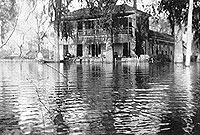 Neals Landing. Photo courtesy Florida Photographic Archives. |
1929
Flood.
1930s
Invention of outboard motors.
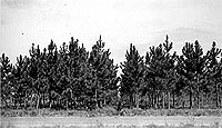 Slash pine established January 12, 1930. Photo taken 1938; courtesy Florida Photographic Archives. |
1930-31
Oyster season is one of the worst on record.
1931
Gulf Intracoastal Waterway extended from Pensacola to Carrabelle
1931
Clifford C. Land founds his turpentine operation in Tates Hell, starting at High Bluff and moving to Greenpoint 2 years later. At High Point a commissary, an office and shanties for the workers were built.
1935
The newly constructed John Gorrie Bridge connects Apalachicola to Eastpoint and points beyond.
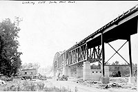 Photo courtesy Florida Photographic Archives. |
1940
The steamer George W. Miller makes three trips a month to Columbus, Georgia, carrying freight and passengers from Apalachicola.
1940
Crabmeat factory established in Apalachicola. Seafood industry breaks record with 112,089 pounds of seafood and 51,700 gallons of oysters.
1940s
Florida torreya is the most conspicuous tree in the ravines
1940s and 1950s
Chattahoochee is the second busiest rail freight port in the state next to Jacksonville.
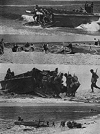 Photo courtesy Florida Photographic Archives. |
1942
German U-boat torpedoes and sinks the British ship Empire Mica British off Cape San Blas. The Coast Guard vessel Sea Dream and another vessel the Countess rescued 14 British soldiers.
1946
Congress passes the River and Harbor Act authorizing the Corps of Engineers to maintain a 100-foot wide, 9-foot deep channel form Apalachicola to Columbus Georgia.
1947
Construction begins on the Jim Woodruff Lock and Dam in the Apalachicola River to facilitate maintenance of the barge canal.
Edward Mueller writes in Perilous Journey: “The U.S. Army Corps of Engineers was striving to improve the river, but many veteran river folk believed their efforts were a waste of time…the river was continually cutting new paths and did as it wished and many of the manmade efforts were futile.”
Entrepreneurs envision the Chattahoochee and Apalachicola as crowded with barges and tugs and lined with manufacturing complexes and thriving inland ports. Locks and dams, it was thought, were the key to bringing wealth and prosperity to the river.
1950s and 1960s
Logging of Tupelo
1950s
The last big sawmill in Apalachicola closed.
1950s
End of paddlewheelers when the excursion steamer George W. Miller was removed from the river.
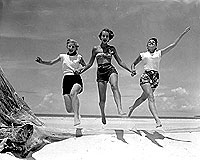 Dorothy Rose Matthews, Pat Baxter, and Ruth Hall, St. George Island, 1952. Photo courtesy Florida Photographic Archives. |
1953
Aerial photos show the first large ditches to drain Tate's Hell Swamp.
1955
Car and passenger ferry service begins from Catpoint to Eastpoint to East Hole on St. George and from Carrabelle to Dog Island
1957
Jim Woodruff Lock and Dam on the Apalachicola becomes fully operational.
Sikes Cut permanently separates St. George and Little St. George islands.
1958
Jim Barkuloo begins research on striped bass. The creeks are in their natural state and you can usually run your boat up into the mouth of the creeks.
Harbor Day in Apalachicola hosts prominent guests from throughout the basin. Jimmie J. Nichols, mayor of Apalachicola, gives Atlanta's mayor William Hartsfield a 1,000 pound anchor and a plaque reading “The Port of Apalachicola salutes the Port of Atlanta”
1972
Florida Water Resources Act creates five water management districts
1972
Army Corps of Engineers proposes spending $200 million to turn river into barge canal.
1973
The State of Florida purchases 1,883 acres on the eastern tip of St. George Island through the Florida Environmental Land and Water Management Act.
1975
The U.S. Army Corps of Engineers proposes to build a low level navigational dirt dam on the Apalachicola River between Bristol and Blountstown. The dam was never built because of strong opposition from Franklin County Commissioners, the Apalachicola Bay seafood industry, Floirda state officials, and conservationists statewide.
1979
Conservation and Recreation Lands (CARL) trust fund established.
1979
The Apalachicola National Estuarine Sanctuary created by the Office of Coastal Zone Management, a branch of NOAA.
1981
Drought.
1983
Water Quality Assurance Act.
1983
The governors of Alabama, Florida and Georgia and the Corps sign a memorandum of agreement to develop a water management plan for the ACF basin.
1984
Warren S. Henderson Wetlands Protection Act.
1984
Hurricane.
1985
Hurricanes.
1985
Gibson Inn in Apalachicola reopens.
1988
Drought.
1988
Old John Gorrie Bridge replaced.
1989
Corps releases a proposal to reallocate water in Lake Lanier from hydropower to water supply for the Atlanta Metro Area.
1990
The state of Alabama files a lawsuit against the Corps.
1992
The governors of Alabama, Florida, and Georgia and Assistant Secretary of the Army sign a memorandum of agreement to work together to resolve water resource issues.
1992
The state acquires the first portions of Tate's Hell.
1994
Tropical Storms Alberto and Beryl and Hurricane Opal flood Panhandle
1994
Amendment three of the Florida Constitution, otherwise known as the net ban, is approved by voter referendum. The amendment bans all gill and entanglement nets from nearshore waters.
1995
$20 million compensation program for those harmed by the net ban passed by the legislature.
1996
The state of Florida establishes the Ecosystem Management and Restoration Trust Fund.
1997
President Clinton signs the ACF basin compact into law.
1998
ACF Compact extended.
2000
ACF Compact extended.
2002
Governor Jeb Bush and Florida cabinet vote unanimously for a resolution to end dredging on the Apalachicola River.
2003
Compact terminated without agreement.
2004
St. Joe Company proposes 7 new residential areas, 3 new commercial sites, and an industrial area in eastern Franklin County. At their SummerCamp site, the company plans to build 499 homes, stores, and an inn on 784 acres.
Note: The content of the website has not been updated since 2005. The site remains online for it's value as legacy content and is unlikely to be updated.